


Pont du Villard - Antennes La Plane

motardes04
User
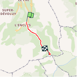

Length
4.3 km

Max alt
1967 m

Uphill gradient
601 m
Km-Effort
10.4 km

Min alt
1354 m

Downhill gradient
4 m
Boucle
No
Creation date :
2015-02-09 00:00:00.0
Updated on :
2015-02-09 00:00:00.0
3h00
Difficulty : Easy

FREE GPS app for hiking
 SityTrail
IGN / Geographical institutes
SityTrail Plus
The world is yours!
About
Trail Snowshoes of 4.3 km to be discovered at Provence-Alpes-Côte d'Azur, Hautes-Alpes, Le Dévoluy. This trail is proposed by motardes04.
Description
Non enregistré sur le GPS. Itinéraire reconstitué.
Positioning
Country:
France
Region :
Provence-Alpes-Côte d'Azur
Department/Province :
Hautes-Alpes
Municipality :
Le Dévoluy
Location:
Saint-Étienne-en-Dévoluy
Start:(Dec)
Start:(UTM)
733905 ; 4950340 (31T) N.
Comments